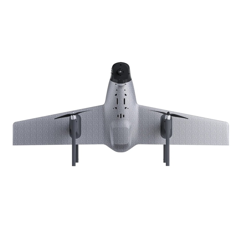
Product Description for HEQ Swan-K1 Mapping Fixed-wing Aircraft
Product Overview:
The HEQ Swan-K1 Mapping is an advanced VTOL (Vertical Take-Off and Landing) fixed-wing aircraft specifically designed for high-precision mapping and surveying tasks. Featuring a newly upgraded dual-frequency PPK (Post Processed Kinematic) system, this aircraft provides exceptional accuracy and efficiency in aerial mapping operations. It is a lightweight, portable, and easy-to-assemble drone, perfect for professional use in surveying, construction, agriculture, and environmental monitoring.
Key Features:
- Newly Upgraded Dual-Frequency PPK: Ensures high-precision mapping and surveying results.
- GCPs-Free Control Measurement: Achieves centimeter-accurate maps without ground control points.
- Vertical Takeoff and Landing: Capable of VTOL and switching flight modes with one button for versatile operation.
- No Rudder Surface Control Technology: Provides a minimalist control experience for users.
- Long Flight Time: Capable of staying airborne for up to 60 minutes.
- High-Precision Positioning: Accurate GNSS positioning for reliable data collection.
- High-Resolution Camera: Equipped with a custom 24 million pixels SONY camera.
- Quick Disassembly Design: Allows for easy and fast assembly within 3 minutes.
- Efficient Coverage: Capable of mapping areas from 2-3 km to 8-9 km depending on flight height and scale.
Detailed Specifications:
Aircraft Parameters
| Parameter | Details |
|---|---|
| Wingspan | 1.1 meters |
| Empty Aircraft Weight | 1.12 kilograms |
| Flight Duration | 50-60 minutes |
| Flight Speed | 10m/s to 25m/s |
| Range | 35-40 kilometers |
| Maximum Takeoff Weight | 1.75 kilograms |
| Maximum Flight Altitude | 500 meters |
| Wind Resistance Level | Level 5 |
| Image Transmission Distance | 3-5 kilometers (unobstructed) |
| Remote Controller Frequency Band | 2.400-2.483GHz |
| Image Transmission Resolution | High Definition |
| Package Dimensions | 580mm x 470mm x 202mm |
Camera Parameters
| Parameter | Details |
|---|---|
| Dimensions | 75 x 65 x 90mm |
| Effective Pixels | 24.3 million pixels |
| Camera Format | APS format camera |
PPK Module
| Parameter | Details |
|---|---|
| GNSS | BDS B11/B21/B31; GLONASS L1/L2; QZSS L1/L2/L5; Galileo E1/E5a/E5b; GPS L1C/A/L2P(Y)/L2C/L5 |
| Data Storage Space | 6GB |
| Data Format | RINEX |
| Horizontal Accuracy | 0.8 cm + 1 ppm |
| Vertical Accuracy | 1.5 cm + 1 ppm |
Achievement Showcase:
- High-Precision Mapping: Capable of achieving 1:500 scale mapping with flight heights up to 210 meters.
- Wide Coverage: Efficiently maps areas from 2-3 km at 1:500 scale to 8-9 km at 1:2000 scale.
Work Efficiency:
- 1:500 Scale: Flight Height: 210 meters, Area Coverage: 2-3 km
- 1:1000 Scale: Flight Height: 420 meters, Area Coverage: 4-5 km
- 1:2000 Scale: Flight Height: 840 meters, Area Coverage: 8-9 km
Applications:
The HEQ Swan-K1 Mapping is ideal for a variety of professional applications, including:
- Land and Property Surveying
- Construction Site Mapping
- Agricultural Field Analysis
- Environmental Monitoring
- Urban Planning
- Energy Projects
- Road Construction Projects
- Mine Surveying
Packing List:
- 1 x Swan-K1 aircraft
- 1 x custom 24 Mega pixels SONY camera
- 2 x set of quick detachable nylon propellers
- 1 x radio controller (with screen)
- 1 x Carry case
- 2 x 5500mAh 15.2V Lipo Battery
- 1 x Power charger
- 1 x Aircraft User Manual and Disclaimer
- 1 x PPK module (Dual frequency)
Summary:
The HEQ Swan-K1 Mapping Fixed-wing Aircraft combines high performance with ease of use, making it an excellent choice for both professional and recreational users. With core parameters like a 60-minute flight time, long-range image transmission, and advanced gimbal stabilization, this drone ensures reliable and precise operations across a variety of aerial applications. The quick-disassembly design and user-friendly features make it a practical and efficient tool for security inspections and other professional uses.
Introducing the HEQ Swan-K1 Mapping VTOL Aircraft, featuring a newly upgraded dual-frequency PPK module and showcasing exceptional work efficiency, with flight durations of 50-60 minutes, speeds up to 25m/s, and ranges of 35-40km.
Reviews
There are no reviews yet.