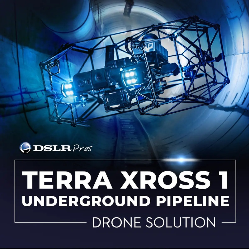
GPS-Free LiDAR Inspection Drone for Underground and Enclosed Pipeline Infrastructure
The DSLRPros Underground Pipeline Drone Solution is a complete aerial inspection system purpose-configured for utility companies, municipal water and sewer departments, oil and gas pipeline operators, and civil engineering firms that need reliable visual and spatial data from inside underground and enclosed pipeline infrastructure.
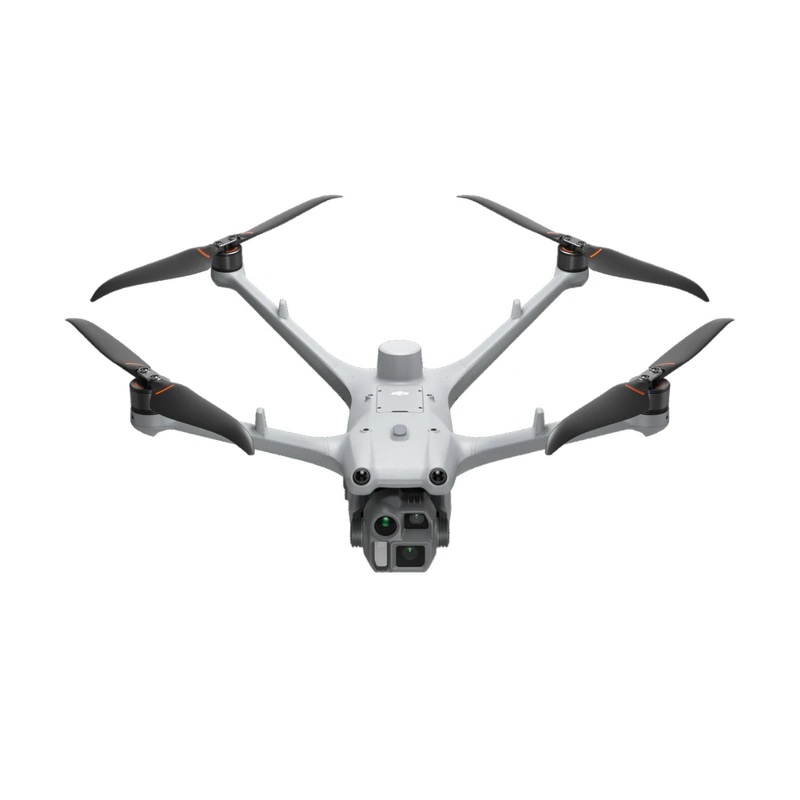
Built around the TerraDrone Terra Xross 1 a Japan-manufactured indoor inspection drone the system uses a Class 1 LiDAR sensor and visual odometry to maintain stable, self-correcting flight inside pipe runs, utility corridors, and subsurface structures where GPS signals are completely absent. Everything needed for immediate field deployment ships in a single kit.
Key Features and Benefits
- GNSS-free navigation: LiDAR and visual odometry hold stable position inside GPS-denied underground pipe environments.
- LiDAR range: Class 1 sensor covers 131 ft (40m) at 10% and 230 ft (70m) at 80% surface reflectivity.
- Range precision: 2cm accuracy at 10 meters supports detailed spatial mapping of interior pipe geometry.
- 4K video: 1/1.7-inch, 8MP sensor captures 3840×2160 footage at 25fps for high-resolution defect documentation.
- Camera tilt: 180-degree tilt covers the full interior circumference of pipe walls and overhead structures.
- Pipeline lighting: Dual LED arrays deliver up to 10,480 lumens for clear footage in completely unlit conduits.
- Protective cage: Full-enclosure frame tolerates incidental pipe wall contact and keeps the aircraft operational.
- Dust resistance: Ingress protection supports sustained operation in silt, particulate, and debris-laden pipe interiors.
- Three-battery kit: Three 5,200mAh batteries provide up to 30 minutes of total flight time per deployment session.
- Terra Xross Cloud: Links inspection video and images to 3D spatial data for structured pipeline reporting.
For pipeline inspection programs, the gap between what needs to be documented and what standard drone platforms can access has always been significant. Underground infrastructure is dark, confined, GPS-denied, and often filled with particulates conditions that eliminate most commercial UAS options before the first flight.
The Terra Xross 1 addresses each of those constraints directly: its full-enclosure protective cage handles contact with pipe walls, its dual LED arrays output up to 10,480 lumens in complete darkness, and its LiDAR system generates real-time 3D point cloud data at 200,000 points per second to keep the aircraft spatially aware at all times.
The result is a platform that can document pipeline conditions with 4K video and actionable spatial data in environments that previously required manual entry or specialized crawler equipment.
Pipeline Inspection Data Without Sending People Underground
Sending personnel into underground pipeline infrastructure for visual inspection carries significant safety risk and operational cost confined space entry protocols, atmospheric monitoring, standby rescue teams, and extended work windows all add up before a single photo is taken.
The DSLRPros Underground Pipeline Drone Solution changes that equation by putting a stable, sensor-driven aerial platform into the pipe instead. The Terra Xross 1’s LiDAR system operates at 10Hz with 2cm range precision at 10 meters, giving the aircraft enough spatial data to navigate narrow pipe geometry accurately while the operator monitors a live 3D feed from the included tablet controller.
The 4K camera and 10,480-lumen LED output ensure that cracks, corrosion, joint separation, sediment buildup, and other structural indicators are captured with enough resolution to be actionable in a report. For pipeline programs running inspection cycles across multiple assets, the Terra Xross Cloud platform ties each flight’s visual output to its spatial coordinates, creating a consistent, searchable record that supports condition trending over time.
Compatibility and System Integration
- Terra Xross Cloud: Links pipeline inspection footage and stills to real-time 3D LiDAR point cloud records.
- Dedicated tablet: Included tablet provides live 3D spatial monitoring and video feed during underground operations.
- Controller interface: Direct controller-to-tablet cable connection delivers integrated ground station functionality.
- 2.4GHz ISM band: Standard RF frequency supports operation in varied underground and enclosed environments.
- Battery cycling system: Shared charger and battery checker enable organized multi-battery rotation in the field.
- Spare propeller set: Four replacement propellers and included wrench support on-site serviceability between runs.
- Lens maintenance kit: Cleaning pen, blower, and cloth maintain camera optics in dusty pipeline environments.
Applications and Use Cases
- Water and sewer main inspection: Documents interior conditions of municipal water distribution and wastewater collection mains.
- Storm drain and culvert survey: Surveys enclosed drainage infrastructure for sediment accumulation, cracking, and joint integrity.
- Oil and gas pipeline inspection: Captures 4K visual and LiDAR spatial data inside transmission and distribution pipe segments.
- Industrial process piping: Inspects interior surfaces of large-diameter process piping inside refineries and manufacturing facilities.
- Utility tunnel and corridor inspection: Maps and documents multi-utility underground corridors and service tunnels with 3D data.
- Pre-rehabilitation condition assessment: Provides visual and spatial baseline data before lining, recoating, or structural repair work.
- Post-construction verification: Confirms interior conditions and joint integrity in newly installed pipeline segments before commissioning.
Underground pipeline infrastructure is expensive to access, hazardous to enter, and difficult to document consistently and the condition data it generates directly informs capital planning decisions worth millions of dollars.
The DSLRPros Underground Pipeline Drone Solution provides inspection teams with the aerial capability to collect that data accurately, repeatedly, and without putting personnel in confined spaces. It is a purpose-matched tool for a problem that conventional inspection methods have never solved efficiently.
DSLRPros has equipped professional UAS operators across infrastructure, public safety, and industrial sectors for decades, and the Underground Pipeline Drone Solution reflects that same commitment to field-ready, mission-specific configuration. Our technical team is available for pre-purchase consultation and ongoing operational support from the first deployment forward.
Order the DSLRPros Underground Pipeline Drone Solution today and give your pipeline inspection program an aerial capability built for the conditions underground.
Reviews
There are no reviews yet.