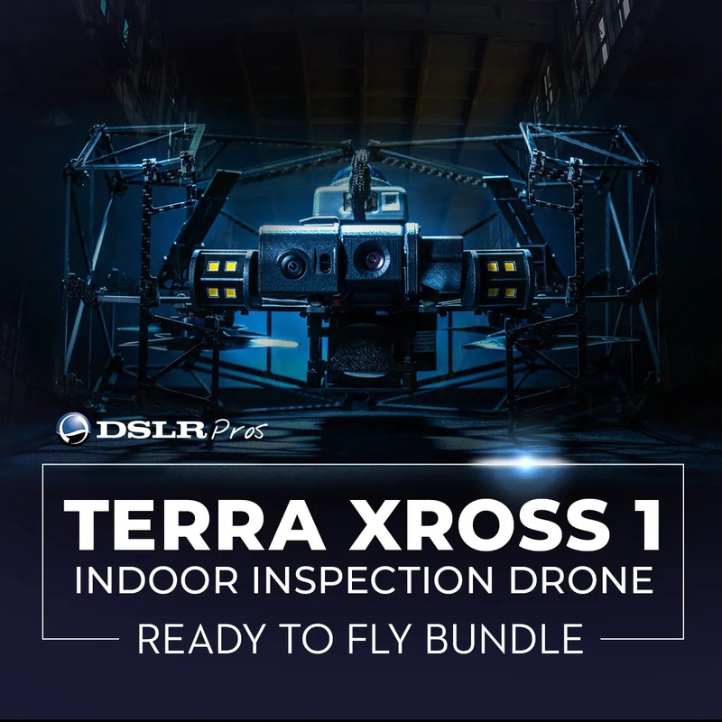
GPS-Free Precision Flight and 4K LiDAR Mapping Out of the Box
The Terra Xross 1 Ready to Fly Bundle is a purpose-built indoor inspection system designed for operators who need to deploy immediately into confined, GPS-denied environments.
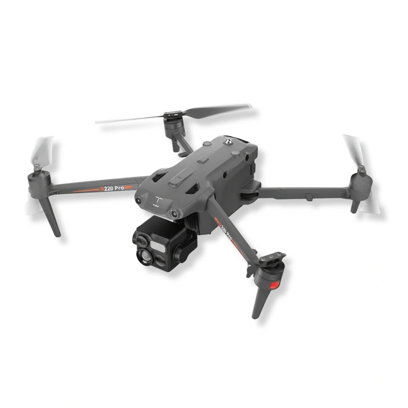
Manufactured in Japan by TerraDrone, the Terra Xross 1 combines a Class 1 LiDAR system with a visual odometry sensor to maintain stable, self-correcting flight inside tanks, tunnels, plant infrastructure, and other structures where satellite navigation is unavailable. Everything required for a complete first mission ships in the box.
Key Features and Benefits
- GNSS-free navigation: LiDAR and visual odometry maintain stable indoor positioning automatically.
- LiDAR range: Class 1 sensor reaches 131 ft (40m) at 10% and 230 ft (70m) at 80% reflectivity.
- 4K camera: 1/1.7-inch, 8MP sensor captures 3840×2160 video at 25 frames per second.
- 180-degree tilt: Camera tilts a full 180 degrees for thorough coverage of overhead structures.
- LED lighting: Dual arrays output up to 10,480 lumens, illuminating dark inspection environments.
- Protective cage: Full-enclosure frame absorbs impact and keeps the aircraft operational mid-mission.
- Real-time 3D mapping: 200,000-point-per-second LiDAR enables BVLOS flight with live obstacle data.
- Dust resistance: Ingress protection keeps internals clean in particulate-heavy industrial environments.
- Three-battery kit: Three included 5,200mAh batteries extend total available flight time per deployment.
- Terra Xross Cloud: Links captured images and video directly to 3D point cloud data for team review.
Engineered for field professionals in industrial inspection, infrastructure maintenance, and facilities management, the Terra Xross 1 delivers 4K video at 25fps alongside real-time 3D point cloud data at 200,000 points per second.
Its full-enclosure protective cage keeps the aircraft airworthy even after contact with surfaces, and dual LED arrays outputting up to 10,480 lumens eliminate the need for separate lighting equipment in dark or visually degraded interiors.
Precise Positioning Where GPS Cannot Reach
Indoor inspection has historically required either rope access or ground-based crawlers, both of which are slow and carry inherent risk. The Terra Xross 1 changes that calculus by fusing LiDAR-based ranging with visual odometry to hold position accurately without any external signal infrastructure.
With 2cm range precision at 10 meters and a 10Hz frame rate, the system builds an actionable 3D map in real time while the operator maintains situational awareness through the tablet controller. The 4K camera and high-output LED lighting together mean irregularities, cracks, and structural anomalies are visible as captured, not discovered after the fact in post-processing.
For organizations running repeated inspection cycles on the same assets, the Terra Xross Cloud platform provides a structured record that links visual evidence directly to spatial coordinates, shortening reporting time and improving traceability across inspection teams.
Compatibility and System Integration
- Terra Xross Cloud: Integrates captured video and stills with real-time 3D LiDAR point cloud data.
- Included tablet: Dedicated tablet connects directly to the controller for live flight monitoring.
- 2.4GHz ISM band: Standard operating frequency compatible with conventional RF field environments.
- 5,200mAh battery system: Three included batteries use a shared charger for streamlined field cycling.
- Battery checker: Included checker allows individual cell health monitoring between flight cycles.
- Spare propeller set: Four replacement propellers ship with the bundle for immediate field serviceability.
- Hexagonal wrench: Included tool enables propeller removal and replacement without additional equipment.
Applications and Use Cases
- Tank and vessel inspection: Surveys interior surfaces of storage tanks and pressure vessels without confined-space entry.
- Bridge and tunnel assessment: Documents structural conditions in enclosed infrastructure where GPS is blocked.
- Industrial plant inspection: Accesses elevated equipment, ductwork, and overhead structures inside facilities.
- Power generation facilities: Inspects boilers, chimneys, and internal turbine structures with 4K visual data.
- Building and facility management: Conducts interior condition surveys for maintenance planning and reporting.
- Utilities and pipeline infrastructure: Inspects interior pipe runs and utility corridors with LiDAR mapping.
- Search and recovery support: Navigates dark, debris-filled interior spaces using LED lighting and real-time 3D data.
The Terra Xross 1 addresses a specific and persistent problem in industrial inspection: how to get consistent, high-resolution visual and spatial data inside structures where people cannot easily go and GPS does not work. Its LiDAR-driven positioning system handles the hard part automatically, leaving the operator free to focus on the asset rather than the aircraft. Mission after mission, it delivers the documentation that inspection programs depend on.
DSLRPros has spent decades supporting professional UAS operators across public safety, industrial, and infrastructure sectors, and the Terra Xross 1 Ready to Fly Bundle reflects exactly the kind of purpose-built, deployment-ready system our customers rely on.
When you purchase through DSLRPros, you get direct access to our technical team for pre-deployment consultation and ongoing operational support. Order the Terra Xross 1 Ready to Fly Bundle today from DSLRPros and put a complete indoor inspection system to work on your next mission.
Reviews
There are no reviews yet.