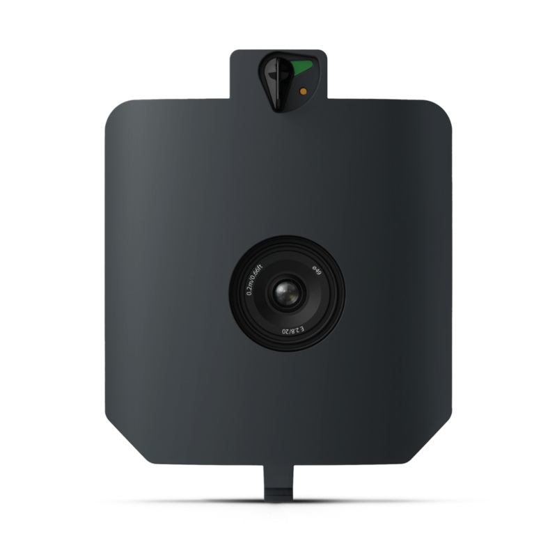
TheWingtraRAY SURVEY24 Payload features a 24 MP APS-C sensor and a low-distortion 20 mm lens, enabling reliable 2D photogrammetry at 2.4 cm (0.94 in) GSD. Cover up to 330 ha (820 ac) per flight at 400 ftan ideal solution for topographic, stockpile, and general mapping projects where cost-efficiency and accuracy are both essential.
Features
- Cost-effective mapping: Accurate performance without the high-end price.
- Large coverage: map up to 820 ac in one mission for earthworks, agriculture, and stockpiles.
- Upgrade-ready: a quick-swap mount enables seamless integration of advanced sensors as requirements grow.
- Seamless workflow: process orthos and DSMs in WingtraCLOUD for same-day deliverables.
High Quality, Swappable and Durable
- Unwavering aerial image quality:Thanks to their heavy payload capacity, the Wingtra drones carry the highest quality sensors on the market.
- Keep a lean fleet:Effortlessly switch between sensors, including high-resolution RGB cameras, multispectral sensors and advanced LIDAR, on the same drone platform.
- Protected from landing shock:Thanks to the smooth vertical landing, your high-quality sensors are always protected, even in rough environments, ensuring a longer lifespan.
Applications
- Mining and Metals:Ensure accurate exploration and effective reclamation strategies with precise terrain mapping.
- Construction and Infrastructure:Ensure project feasibility and optimal design with detailed greenfield surveys and precision earthwork planning.
- Urban Planning and Land Management:Drive informed planning and sustainable development with comprehensive greenfield surveys.
- Environmental Monitoring:Monitor environmental changes and simulate floods for more effective ecological management and planning.
WingtraRAY SURVEY 24 Payload – The Affordable Mapping and Surveying Solution
Compatibility
WingtraRAY
In the Box
1 – SURVEY 24 Payload including mount for WingtraRAY
1 – Storage device
Specifications
| Sensor | 24.2 MP APS-C, focal-plane shutter |
| Lens / focal length | 20 mm (0.79 in) nadir |
| GSD @ 400 ft (120 m) | 2.4 cm/px (0.94 in/px) |
| Lowest GSD | 1.2 cm/px (0.47 in/px) @ 200 ft (61 m) |
| Max coverage @ 400 ft | 330 ha (820 ac) 83 % frontal overlap |
| Max coverage @ lowest GSD | 170 ha (420 ac) |
| Accuracy (PPK, no GCPs) | 3 cm / 0.1 ft RMS (X, Y, Z) |
| Payload weight (incl. mount) | 550 g (1.21 lb) |
| Pixel dimensions | 6 000 4 000 |
| Minimal trigger time | 1.0 s Min. trigger distance 8 m (26 ft) |
| Coverage assumptions | 60 % side-overlap, calm conditions |
Reviews
There are no reviews yet.