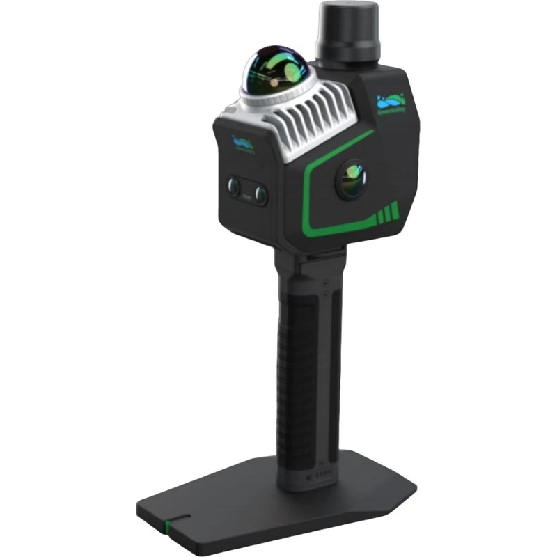
GreenValley LiGrip O2 Lite All-Scenario Handheld SLAM LiDAR Scanner, MLF-SLAM + RTK-SLAM, 1408-Ch GNSS, Dual 12MP Panoramic Cameras, Real-Time Colorization
The GreenValley LiGrip O2 Lite is the latest-generation handheld SLAM LiDAR scanner from GreenValley International (GVI), built for all-scenario 3D mapping including challenging featureless environments such as airports, beaches, and open terrain. It utilizes GVIs proprietary MLF-SLAM (Multiple Localization Fusion-SLAM) multi-sensor fusion technology, combining LiDAR-SLAM, Visual SLAM (VSLAM), RTK-SLAM, and PPK-SLAM to achieve centimeter-level accuracy across all environments. The dual 12MP panoramic cameras provide microsecond-level synchronization for realistic scene colorization, while the self-developed RTK-SLAM mode enables <5cm accuracy in under 1 minute even without GNSS signal. The 1408-channel RTK GNSS delivers H:0.8cm+1ppm / V:1.5cm+1ppm accuracy with NTRIP differential protocol. Outputs include colored point clouds (LAS/LiData), panoramic imagery (JPG), LOD-OSGB mesh, and Gaussian Splatting (lisplat/ply). Available with frontpack kit (2.1kg) or backpack kit (3.9kg, hot-swap dual battery). Compatible with LiGrip H Series and O Series accessories.
Key Features
- MLF-SLAM Technology Multi-sensor fusion: LiDAR-SLAM + VSLAM + RTK-SLAM + PPK-SLAM
- <5cm Accuracy in 1 Minute Even without GNSS signal via RTK-SLAM mode
- All-Scenario Mapping Featureless environments (airports, beaches, rivers) no longer a challenge
- Dual 12MP Panoramic Cameras Microsecond-level sync, VSLAM + LiDAR-SLAM deep fusion
- 1408-Channel RTK GNSS BDS, GPS, GLONASS, Galileo, QZSS, SBAS
- RTK Accuracy: H:0.8cm+1ppm / V:1.5cm+1ppm NTRIP differential, RTCM V3.X
- 200Hz IMU 0.005 roll/pitch, 0.010 heading (post-processed)
- Real-Time Processing & Colorization Instant colored point cloud output in the field
- Multiple Output Formats LAS/LiData point clouds, LOD-OSGB mesh, Gaussian Splatting (lisplat/ply), panoramic JPG
- Frontpack Kit 2.1kg, 560340160mm
- Backpack Kit 3.9kg, 580303145mm, hot-swap dual battery with power display
- Telescopic Pole Adapter 300g, 2525.5mm pole diameter, compatible with LiGrip O Series
- OEM/ODM/OBM Customization Available
- 1-Year Warranty
Professional Applications
- Indoor and outdoor 3D mapping in all environments
- Featureless terrain mapping (airports, beaches, open fields, rivers)
- Building information modeling (BIM) and as-built documentation
- Infrastructure inspection and corridor surveys
- Urban mapping and digital twin creation
- Gaussian Splatting and photorealistic 3D reconstruction
- UAV-mounted and backpack mobile mapping
Technical Specifications
RTK Parameters
- Channels: 1408
- Satellite Systems: BDS (B1I/B2I/B3I/B1C/B2b), GPS (L1C/A/L2C/L2P/L5), GLONASS (G1/G2), Galileo (E1/E5a/E5b/E6), QZSS (L1C/A/L2C/L5), SBAS (L1C/A)
- RTK Accuracy: H: 0.8cm+1ppm | V: 1.5cm+1ppm
- Differential Protocol: NTRIP
- Differential Data: RTCM V3.X
- RTK Data Format: .rtk
IMU Parameters
- Output Frequency: 200Hz
- Post-Processing Position Accuracy: H: 0.01m | V: 0.02m
- Post-Processing Attitude Accuracy: Roll/Pitch: 0.005 | Heading: 0.01
Mapping Methods
- Principles: MLF-SLAM, PPK-SLAM, RTK-SLAM, SLAM
- Real-Time Processing: Supported
- Real-Time Colorization: Supported
Output Formats
- Colored Point Cloud: LAS, LiData
- Panoramic Image: imglist + JPG
- Mesh: LOD-OSGB
- Gaussian Splatting: lisplat, ply
Frontpack Kit
- Weight: 2.1kg
- Dimensions: 560340160mm
- Compatibility: LiGrip H Series and O Series
Backpack Kit
- Weight: 3.9kg
- Dimensions: 580303145mm
- Dual Battery Hot Swap: Supported
- Compatibility: LiGrip O2 Series
Telescopic Pole Adapter
- Weight: 300g
- Pole Diameter: 2525.5mm
- Compatibility: LiGrip O Series (O1 Lite and O2 Lite)
Important Notes
- High-value enterprise product contact us for bulk pricing and shipping logistics
- Sea freight recommended due to battery regulations confirm shipping timeline before ordering
- OEM/ODM/OBM customization available
- 1-year warranty included
Reviews
There are no reviews yet.